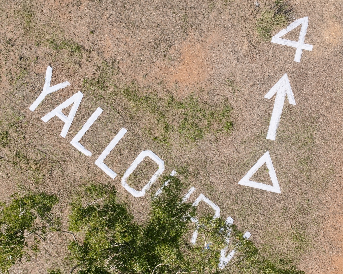
The first word surrendered immediately.
YALLOURN.
The remaining symbols kept their counsel.
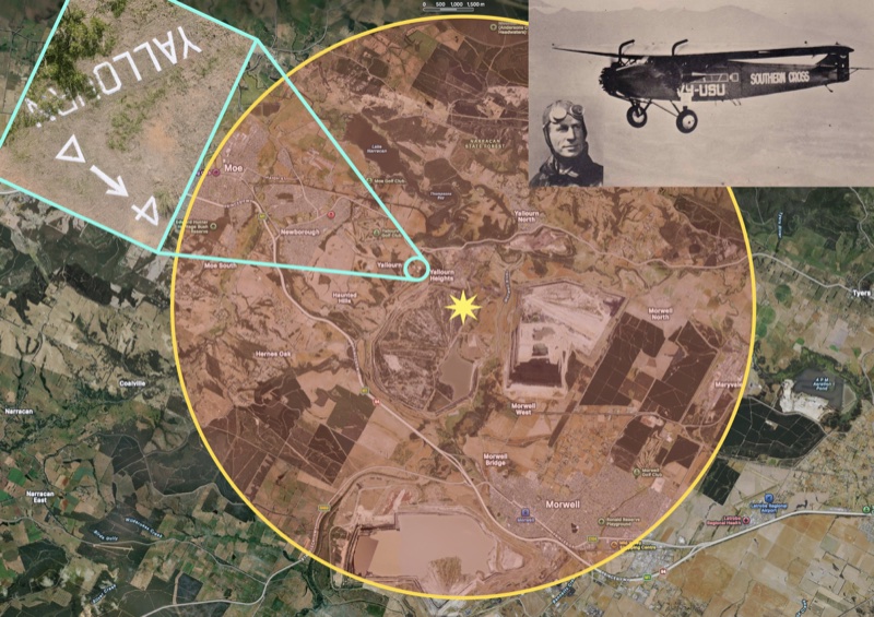
The letters lie beside the former Yallourn reservoirs, across open ground on the hill above the town that once stood below. Each appears to be approximately one-and-a-half metres high. Beyond the town’s name sits an outlined triangle, followed by an arrow approximately four metres long and a separate concrete numeral 4.
The arrangement was made to be read from the air. We gave its unexplained final sequence a name worthy of a case file from the golden age of aviation.
Delta 4.
Local recollection placed the marker at the beginning of the Second World War. Steve Cox recorded on the Virtual Yallourn history site that it served as a direction indicator for aircraft, showing pilots where they were and alerting them that they were entering a restricted zone. He also remembered that the marker had been illuminated and that its lights remained until approximately 2008.
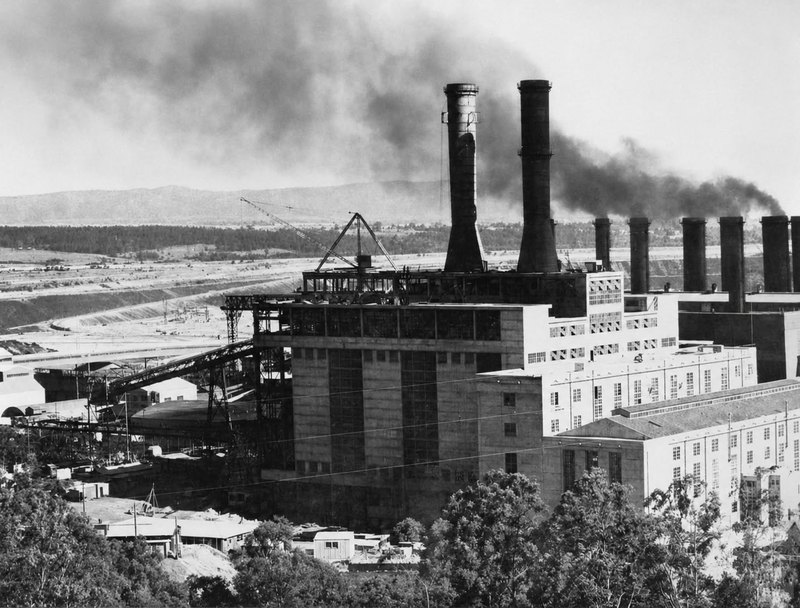
Yallourn’s wartime importance is firmly established. Its power stations, open cut, briquette works and transmission network formed one of Victoria’s most strategically important industrial complexes. Anti-aircraft guns guarded Yallourn and Yallourn North, sensitive sites operated under strict control, blackout measures changed life across the town and the airspace above the complex was declared prohibited.
Local accounts describe an RAAF aircraft entering that prohibited airspace on the day Japan entered the war. The anti-aircraft crews opened fire, giving the people below a frightening demonstration of the protection surrounding Victoria’s electricity supply.
The wartime explanation carried authority because it belonged to a true history. The physical evidence then began leading the investigation towards an earlier story.
The marker stood only about one to one-and-a-half kilometres from the former Yallourn township. An aircraft flying low enough to locate and read letters approximately one-and-a-half metres high would already be over the reservoirs and within seconds of the town. The marker’s position and scale suit a pilot using landmarks to confirm a location and establish the next course.
The triangle became the first breakthrough. Its upper point sits close to north. A small difference remains when it is compared with north on a modern digital map, although an early survey may have used magnetic north rather than modern true or grid north. Magnetic north moves gradually over time, allowing a compass-aligned marker from the 1930s to sit several degrees away from north today.
The triangle appears to orient the pilot.
The arrow then points away from Yallourn towards the Morwell district. The numeral 4 supplies the final part of the instruction.
Modern aviation expresses navigational distance in nautical miles. Four nautical miles equals approximately 7.4 kilometres. Four ordinary statute miles equals approximately 6.4 kilometres. Early local aerial markers could use ordinary miles, particularly when constructed outside the later standardised systems of aviation navigation.
Either measurement carries the eye from Yallourn towards the Morwell landing-ground corridor.
For a time, White City Airfield appeared to provide the answer. The Latrobe Valley Aero Club formed in 1949, largely through the enthusiasm of former servicemen who had learned to fly during the war. Its early activities took place from a farm paddock immediately west or south-west of Morwell, remembered as the White City airfield. The club operated Tiger Moths, provided flying training and helped establish a lasting aviation culture in the Valley.
The State Electricity Commission’s expanding Morwell works eventually encroached upon the field. The club moved to a permanent aerodrome, and the present Latrobe Regional Airport opened to air traffic in 1959.
White City lay broadly along the direction indicated by the arrow, and its approximate distance appeared to fit the 4. It offered a convincing explanation for the marker’s continued use during the postwar years.
Its chronology placed the sign’s original purpose back under investigation.
The early Latrobe Valley Aero Club was a regional organisation serving local training, recreational flying and a developing aviation community. White City emerged after the war. The marker’s reported history reached back into an earlier decade.
Then the case produced a blinding flash of the obvious.
In 1932, Charles Kingsford Smith brought the Southern Cross to Morwell.
This was one of the most famous aircraft in the world, flown by the most celebrated Australian aviator of his generation. Four years earlier, Kingsford Smith and his crew had completed the first trans-Pacific flight from the United States to Australia. The Southern Cross had crossed the Tasman, flown from Australia to England and carried Smithy through achievements that made both pilot and aircraft national icons.
Its arrival in Morwell required preparation.
A suitable landing ground was selected on Budge’s property south of Wallace Street, in an area later absorbed into the open cut. The paddock had to accommodate a large three-engined Fokker carrying considerable weight across an uneven country surface. The route, ground conditions, approach and wind all mattered.
A twelve-year-old Morwell boy named Des Kelly was employed to keep a smoke fire burning at the landing ground. Its purpose was practical and essential: the smoke showed Kingsford Smith the direction of the wind as he prepared to bring the Southern Cross down.
Kelly promptly delegated the fire to another boy and stowed away aboard the aircraft for several local flights.
That adventurous boy went on to become one of the Latrobe Valley’s most important aviation figures. During the Second World War, Des Kelly flew Spitfires and became the first Australian to fly a jet aircraft when he converted to the Gloster Meteor. After returning to Morwell, he became a driving force behind the Latrobe Valley Aero Club and the establishment of the permanent aerodrome that became today’s Latrobe Regional Airport.
The smoke fire confirms that Kingsford Smith’s Morwell arrival was organised in advance. People knew he was coming. A landing field had been selected. Local duties had been assigned. The world-famous Southern Cross needed to find a particular paddock in a landscape without radio beacons, runway lights or modern navigation equipment.
Four miles away, Yallourn possessed an elevated and unmistakable landmark.
The reservoirs stood on high, open ground. The town and power station formed one of the most distinctive industrial landscapes in Gippsland. The State Electricity Commission had surveyors, engineers, concrete workers and the organisational capacity to construct a permanent aerial marker.
A pilot approaching the Latrobe Valley could locate Yallourn, read the name on the reservoir hill and receive the remaining instruction:
YALLOURN — You are here.
TRIANGLE — This is north.
ARROW — Follow this bearing towards Morwell.
4 — The landing ground lies four miles away.
The known circumstances give possibility that the this sign was constructed for Kingsford Smith's visit considerable strength.
The timing works. The direction works. The approximate distance works. The chosen location works. The symbols provide the information an arriving pilot required. The smoke fire waiting at the far end completes the navigational sequence by showing Smithy the wind over the landing paddock.
The evidence gathered strongly points to a heritage object of potential national significance. With appropriate assessment and protection, it could also become a distinctive heritage tourism destination for the Latrobe Valley.
Delta 4 may have been built to guide the Southern Cross into Morwell in 1932.
The marker could then have acquired a long working life. Other pilots used the Morwell landing-ground corridor during the 1930s. Yallourn’s airspace came under military control during the Second World War, attaching the sign to the town’s defensive history. White City Airfield developed after the war along the same general course. The marker continued to identify Yallourn and point pilots towards Morwell as aviation in the Valley moved from paddocks to an organised aero club and eventually to a permanent regional airport.
Its reported illumination also fits this longer history. Lighting could make the marker visible during approved night operations and may have been controlled during wartime blackout conditions. The continued presence of those lights into the early twenty-first century suggests that successive generations maintained the installation long after the immediate danger of wartime attack had passed.
The surviving sign may therefore carry several layers of Latrobe Valley history.
Its first message may have guided Kingsford Smith towards a smoke fire and a waiting crowd in 1932. During the war, it stood within one of Australia’s most heavily defended industrial landscapes. In the postwar years, it remained relevant as local pilots flew from White City. Its final chapter continued after Yallourn disappeared and the permanent airport opened farther east.
One piece of evidence can still close the file.
A contemporary newspaper report may describe the preparations for Smithy’s arrival. An SEC works order may record concrete lettering beside the reservoirs. Morwell Shire minutes may mention an aerial direction sign. An early photograph may show whether Delta 4 existed before the Southern Cross arrived. A map locating Budge’s landing paddock precisely would allow the arrow’s bearing and the four-mile distance to be tested.
Somewhere in an SEC collection, an aviation album, a council file or a family drawer, that evidence may still survive.
The town of Yallourn has disappeared. Budge’s landing ground has disappeared. White City Airfield has disappeared. The Southern Cross departed the Valley more than ninety years ago.
Its path to Morwell may still be written in concrete on the hill.
Yallourn. North. Follow the arrow. Four miles.
Sir John Monash Museum
30 Yallourn Drive, Yallourn
Open
Tuesday 10:00am–2:00pm
Sunday 10:00am–3:00pm