The story became accepted history, repeated often enough that the repetition served as its evidence.
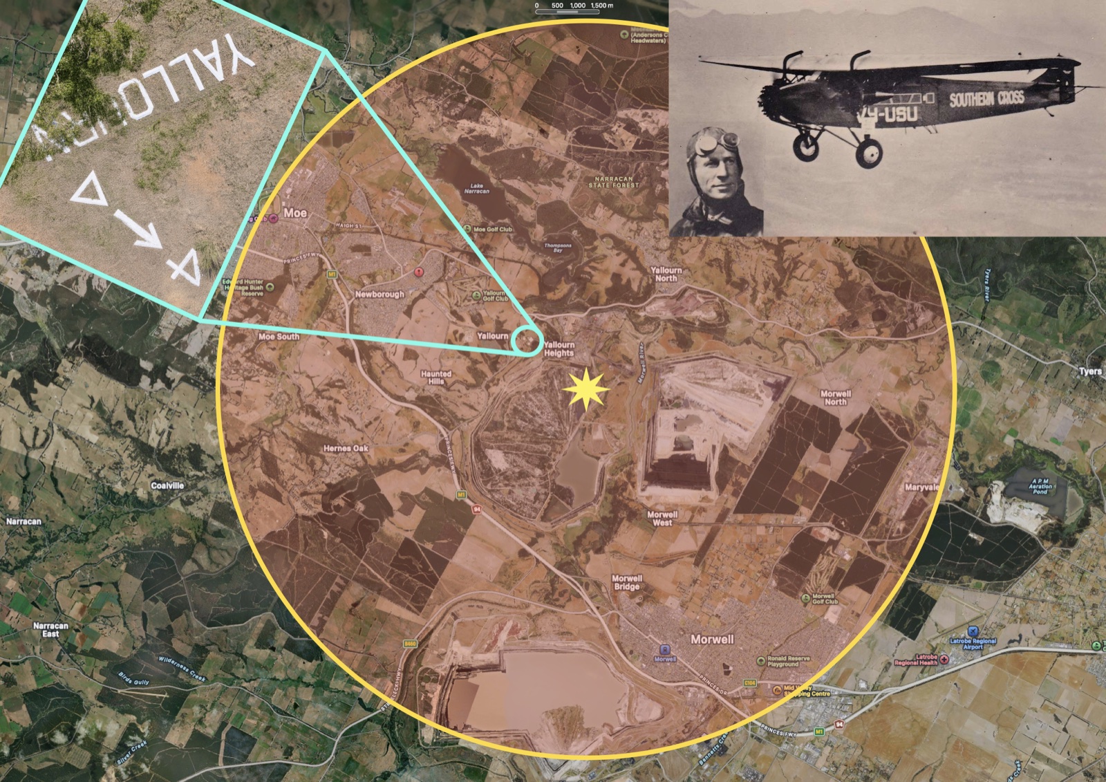
The documented wartime restriction zone is precise. Colin Harvey’s 1993 State Electricity Commission history, Yallourn Power Station: A History 1919 to 1989, records that aircraft were prohibited within a radius of five miles—approximately eight kilometres—from the Yallourn open-cut mine. The mine formed the centre of a protected circle ten miles across.
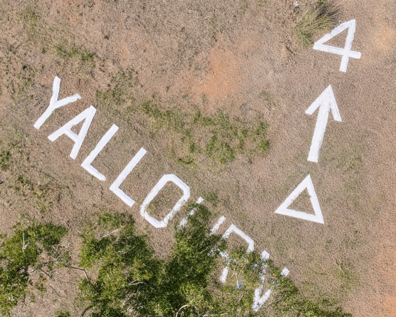
The yellow star marks the Yallourn open cut. The yellow boundary is the five-mile radius. The blue circle shows the concrete sign beside the former reservoirs. The enlarged inset shows the installation in its correct orientation, with YALLOURN, the triangle, the large arrow and the numeral 4 laid out across the hillside.
The blue circle sits deep inside the no fly zone. An aircraft would have already travelled several miles through prohibited air space before the pilot could read the sign.
The sign had no possible function as a warning sign.
Plus, aircraft could approach Yallourn from every direction. A single ground marker at one location inside a 50km circumference could never effectively warn pilots.
Pilots learned about prohibited airspace through published notices, aeronautical charts, coordinates and instructions issued before flight. The five-mile boundary existed on those charts. One place-name written on the ground near the centre could identify Yallourn; it could not tell an approaching pilot where the prohibited area began.
Then the arrow takes the wartime explanation apart completely.
It points directly from reservoir hill through the centre of the exclusion zone towards the Morwell landing-ground corridor.
An aircraft following that bearing would continue across the protected Yallourn landscape, travelling through the airspace above the open cut, power infrastructure and industrial complex the wartime restriction had been established to protect. A sign intended to keep aircraft out was directing them onwards through the prohibited area.
The number beside the arrow is 4. Yallourn’s prohibited radius was 5 miles. The numeral describes something else. Read with the arrow, it supplies the two pieces of information an arriving pilot required: a bearing and a distance.
Every component performs a navigational function. YALLOURN identifies the aircraft’s position. The triangle establishes orientation. The arrow indicates the course to follow. The numeral gives the distance to a landing ground.
Written across the reservoir hill, the complete installation delivered a clear message to the cockpit above:
You are over Yallourn. Establish north. Follow this bearing. The landing ground is four miles away.
The reported lighting of the sign belongs to the same purpose.
Illumination allowed an aviator to establish position when daylight was fading or visibility was poor.
During wartime blackout conditions, if lit, those lights would have been a bullseye for the enemy pointing directly to the location of Victoria’s most important electricity-producing district.
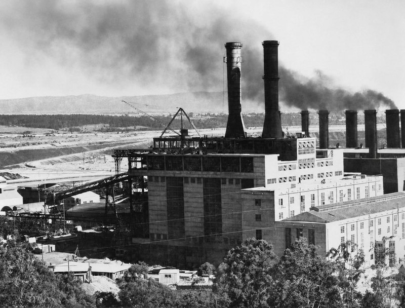
Yallourn’s power stations, open cut and briquette works were protected because Victoria depended upon them. Anti-aircraft positions guarded the district, families covered windows and light was controlled. The illuminated YALLOURN sign on reservoir hill came from an earlier navigational landscape.
Local memory preserved two genuine facts. The concrete sign existed during the war, and Yallourn stood inside a five-mile prohibited-airspace zone.
Over time the wording shifted almost imperceptibly. “The sign existed inside Yallourn’s prohibited airspace” became “the sign marked Yallourn’s prohibited airspace.” Memory retained the objects and events. Later generations supplied an imagined relationship between them.
That process deserves respect because the people who carried the story kept knowledge of the sign alive. Yallourn disappeared, the former reservoir land became inaccessible and the installation passed beyond ordinary public view. Recollections preserved the concrete letters, their lights and their wartime surroundings.
Historical research takes the next step: it places those memories beside the physical evidence and tests the explanation they have carried.
The key element from these memories is that the sign existed during the war. The distinction is that given its location and meaning, it also had no useful purpose during the war.
The installation was therefore built before the war to guide an aircraft known to be flying from the Melbourne direction and arriving to land at a Morwell landing ground. Its position, orientation, arrow and distance establish that function.
One known event accounts for the complete design of the Yallourn sign.
In 1932, Sir Charles Kingsford Smith brought the Southern Cross to Morwell. His arrival was planned in advance. A landing place on the Budge property had been selected and prepared, and a smoke fire was maintained to show wind direction as the aircraft approached.
Kingsford Smith was entering the Latrobe Valley from beyond the district in one of the most famous aircraft in the world. He needed to establish his position, locate the prepared field and approach it on a workable course. The Yallourn installation provided location, orientation, bearing and distance from a high, clearly visible point in the landscape.
The surviving evidence identifies the concrete installation as an aerial navigation marker directing aircraft from Yallourn towards the Morwell landing ground. Kingsford Smith’s planned 1932 arrival is the only known explanation for why an installation of that scale was created. The marker’s navigational function is already written into the ground. (Additional note - It is also reported that in a different aircraft many years earlier, Kingsford Smith landed in Moe.)
This is where the story meets Sir John Monash. His work began with first principles: establish the conditions, take the measurements, test the plan against the ground and follow the consequences. A bridge had to carry its load. An electricity scheme had to match generating capacity with the demands of a growing state. A military plan had to account for distance, terrain, timing, machinery and the people required to carry it out. An explanation earned its authority by surviving contact with physical reality.
Applied to the Yallourn sign, that discipline is exact. Place the known five-mile restriction around the open cut. Mark the sign’s location inside it. Follow the direction of the arrow. Compare the numeral 4 with the documented five-mile radius. Examine the triangle, the orientation and the reported illumination. The wartime story collapses under the weight of its own contradictions, while the navigational purpose becomes clearer with every measurement.
The same discipline matters across local history. Moe is frequently described as an Aboriginal word meaning “swamp,” yet no recorded Aboriginal language includes such a word. “Aboriginal for swamp” is a repeated story rather than an established etymology.
Yet, the district was swampy and the name Moe was in use by 1846. Ironically, Moe is more related to the French 'mouille' meaning wet. Plus at the time ‘mow-ee’ was working class slang for the pace worth mowing. And the Scottish were some of the first Europeans to the region. Old Norse 'mor' means moor, a similar setting to the Moe region. With their boots deep in Gippsland glue two Scotsmen stand in the rain. One calls it a mor. The other adds "aye." Mor-aye. Latrobe Valley's earliest European settlers did use language sounding like Moe to describe grassy swamps.
Local legends often begin with something real. A sign stood within a wartime exclusion zone. A town grew beside wet, swampy country. Memory carried the genuine details forward while time softened the distinctions between association, explanation and fact. The historian’s responsibility is to preserve the memory, return to the evidence and allow each piece to occupy its proper place.
The concrete letters have survived the disappearance of Yallourn, the expansion of the open cut, the closing of White City and more than ninety years of weather on the reservoir hill. Their position, orientation and complete navigational design lead directly back to the planned 1932 arrival of Sir Charles Kingsford Smith in the Southern Cross.
That event accounts for the prominent location, the need to guide an aircraft arriving from beyond the district, the bearing towards the prepared Morwell landing ground and the distance marked beside the arrow.
No comparable ground marker associated with a Kingsford Smith arrival has been identified anywhere else in Australia.
On the evidence available, the Yallourn installation is the only known surviving sign of its kind connected with one of the world's most prominent aviators.
That gives these concrete letters significance extending far beyond the history of Yallourn. They form part of the physical story of Australia’s greatest pioneering aviator and one of the most celebrated aircraft of the twentieth century.
The responsibility to protect the marker already exists. Its concrete elements, original orientation, relationship with the Morwell landing ground and surrounding landscape must be recorded, conserved and preserved in place. Public access and interpretation can then allow Australians to understand what survives on that hill and why it matters.
Local memory carried the Yallourn sign to us. First-principles examination has recovered the purpose written into its design and returned it to the moment that best explains its creation: Sir Charles Kingsford Smith bringing the Southern Cross into the Latrobe Valley in 1932.
Australia possesses no other known marker like it.
Its survival for future generations now depends upon recognising what the evidence has revealed.